
History of the ASRC Whiteface Mountain Field Station
No Mistaken Identity
To truly understand the nature of the name "Whiteface" one has to have a basic understanding of the geology of the Adirondack mountains. Many of them, including Whiteface, are formed primarily from gabbroic anorthosite, an igneous rock with fewer dark crystals, making it almost white. Following erosion from their once Himalayan height, this white rock was left exposed on many of the Adirondack peaks. Landslides that have occurred on Whiteface mountain over the years have also exposed long stretches of the light anorthosite on its slopes.
These characteristics were likely the genesis for the names given to the mountain by early native American and Canadian Indians, as well as for the present-day name "Whiteface." The Algonquin Indians gave the imposing mountain the name "Wa-ho-par-te-nie," which translated roughly means “it is white.” Nomadic Canadian Indians passing through to the Lake Champlain valley called it "Thei-a-no-guen," meaning "white head," and the Mohawk Indians called the mountain "Ou-no-war-lah" or "scalp mountain."
Why Atmospheric Research at Whiteface Mountain?
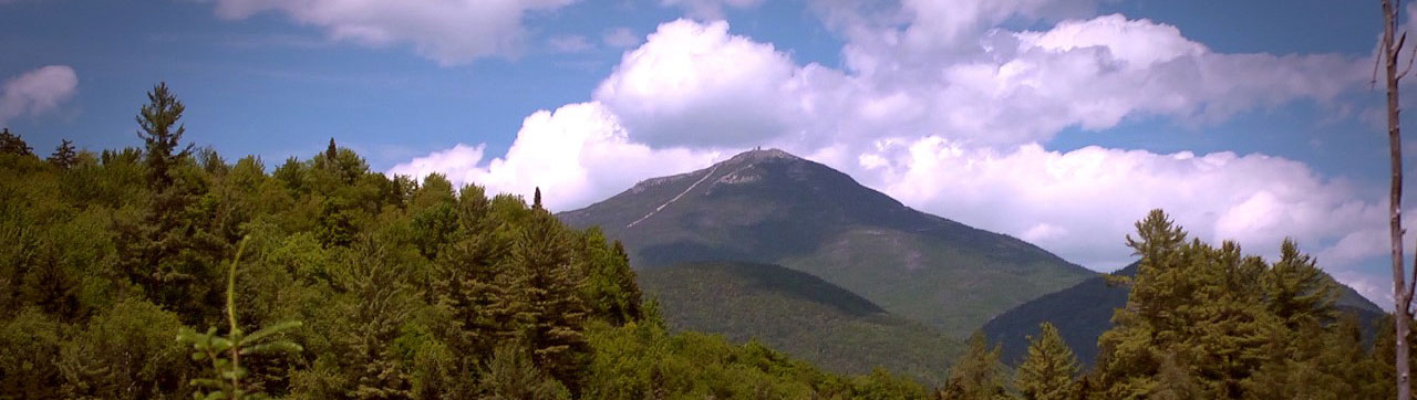
While Whiteface mountain may not be the highest mountain in the Adirondack High Peaks region (it is the fifth highest) its summit is the easiest to access. In 1929, then Governor of New York State, Franklin D. Roosevelt commissioned the Whiteface Veteran’s Memorial Highway be built to just below the summit to honor the veterans of World War I. The Veterans Memorial Highway provides access to within 92 vertical meters of the summit observatory. After approximately five miles and 700m in elevation gain, the highway terminates at a two-story Castle built with granite excavated from the highway construction. A tunnel to the core of the mountain provides access to an elevator with a direct route to the summit roundhouse for equipment and personnel.
(Video: Whiteface Mountain Veterans Memorial Highway Inaugural Ceremony, September 11, 1929. Mp4 (no sound): 97MB, 12:46 duration)In addition to being easily accessible, Whiteface mountain stands as a lone massif at 1,483m above sea level approximately 16km to north of the main Adirondack high peaks. The summit is 90 meters above tree line and is exposed in all directions to wind and cloud. With no land mass higher in the western and northwestern topography for many miles, Whiteface is exposed to the predominant westerly winds making it ideally suited for meteorological and in-situ cloud measurements.
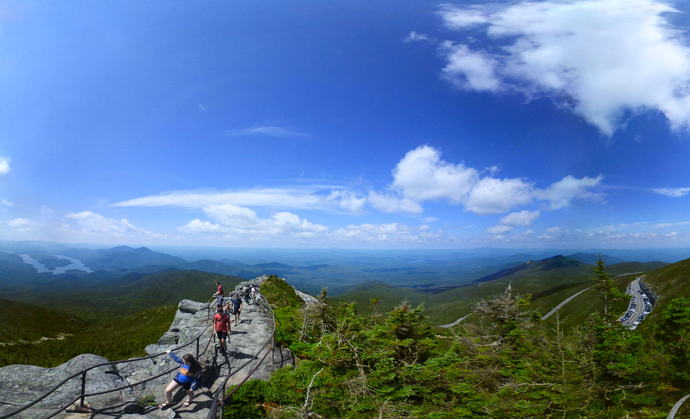 (View looking West/NW on Stairway ridge trail from Castle showing unobstructed westerly aspect)
A Tale of Two Sites
The ASRC Whiteface Mountain Field Station is comprised of two physical sites, the summit observatory and the Marble Mountain Lane site located in Wilmington, New York. Together, the summit and Marble Mountain facilities provide a rich history of long-term meteorological and atmospheric chemistry measurements resulting in the highest quality datasets.
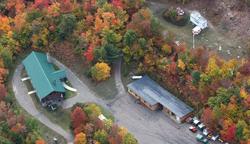 (Marble Mountain Site: N44° 23' 35", W73° 51' 33", 604m ASL. Lower left: main lodge bldg.; Lower right:
research office annex; Upper right: instrument compound including
New York State Mesonet ‘WFMB’ standard
site installed in 1/29/2016)
(Marble Mountain Site: N44° 23' 35", W73° 51' 33", 604m ASL. Lower left: main lodge bldg.; Lower right:
research office annex; Upper right: instrument compound including
New York State Mesonet ‘WFMB’ standard
site installed in 1/29/2016)
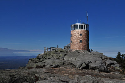
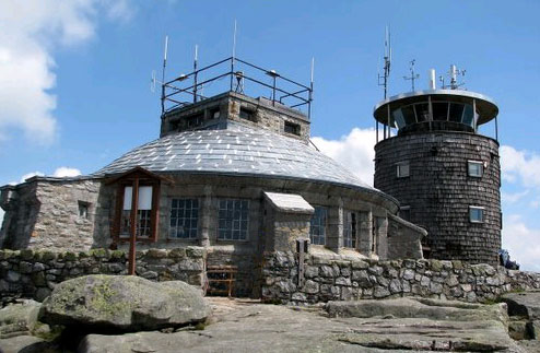 (Summit Site: N44° 21' 58", W73° 54' 10", 1483m ASL.
Elevator roundhouse left, and original observatory tower right)
(Summit Site: N44° 21' 58", W73° 54' 10", 1483m ASL.
Elevator roundhouse left, and original observatory tower right)
Although ASRC was not established until 1961, Vincent Schaefer, one of the founding fathers of ASRC began making meteorological measurements at the summit in 1957. The Whiteface Mountain Authority (now ORDA, the New York State Olympic Regional Development Authority), which operates and manages the Whiteface Ski Center, provided funding for the instrumentation. Schaefer and colleague Ray Falconer installed the instruments and provided daily weather reports for the Ski Center.
In 1961, upon establishment of ASRC as a "system-wide resource for the State University of New York (SUNY)," ASRC assumed operation and management of the Marble Mountain facilities through a memorandum of understanding with the New York State Department of Environmental Conservation (DEC). Then, in 1970, the summit observatory was completed which provided a wealth of sustainable research opportunities at the field station. In 2012, major infrastructure improvements and upgrades were made to the summit observatory after years of exposure to harsh weather extremes. Through strong partnerships with DEC and ORDA, ASRC operates and manages the Whiteface Mountain Field Station for the benefit of all.
 (Current Summit Observatory, Photo Credit: Richard Brandt ASRC WFMFS Science Manager)
Working In The Clouds
 One of the premier research programs that has occurred at Whiteface mountain since the 1970's is cloud
and precipitation chemistry measurements. This was largely driven by the detrimental effects of acid rain
and deposition in the Adirondacks produced from pollutants generated by coal burning power plants many
miles from the region. Ray Falconer (pictured) designed the original cloud water collection system,
which was later improved upon by Dr. Volker Mohnen who eventually became Director of the ASRC
One of the premier research programs that has occurred at Whiteface mountain since the 1970's is cloud
and precipitation chemistry measurements. This was largely driven by the detrimental effects of acid rain
and deposition in the Adirondacks produced from pollutants generated by coal burning power plants many
miles from the region. Ray Falconer (pictured) designed the original cloud water collection system,
which was later improved upon by Dr. Volker Mohnen who eventually became Director of the ASRC
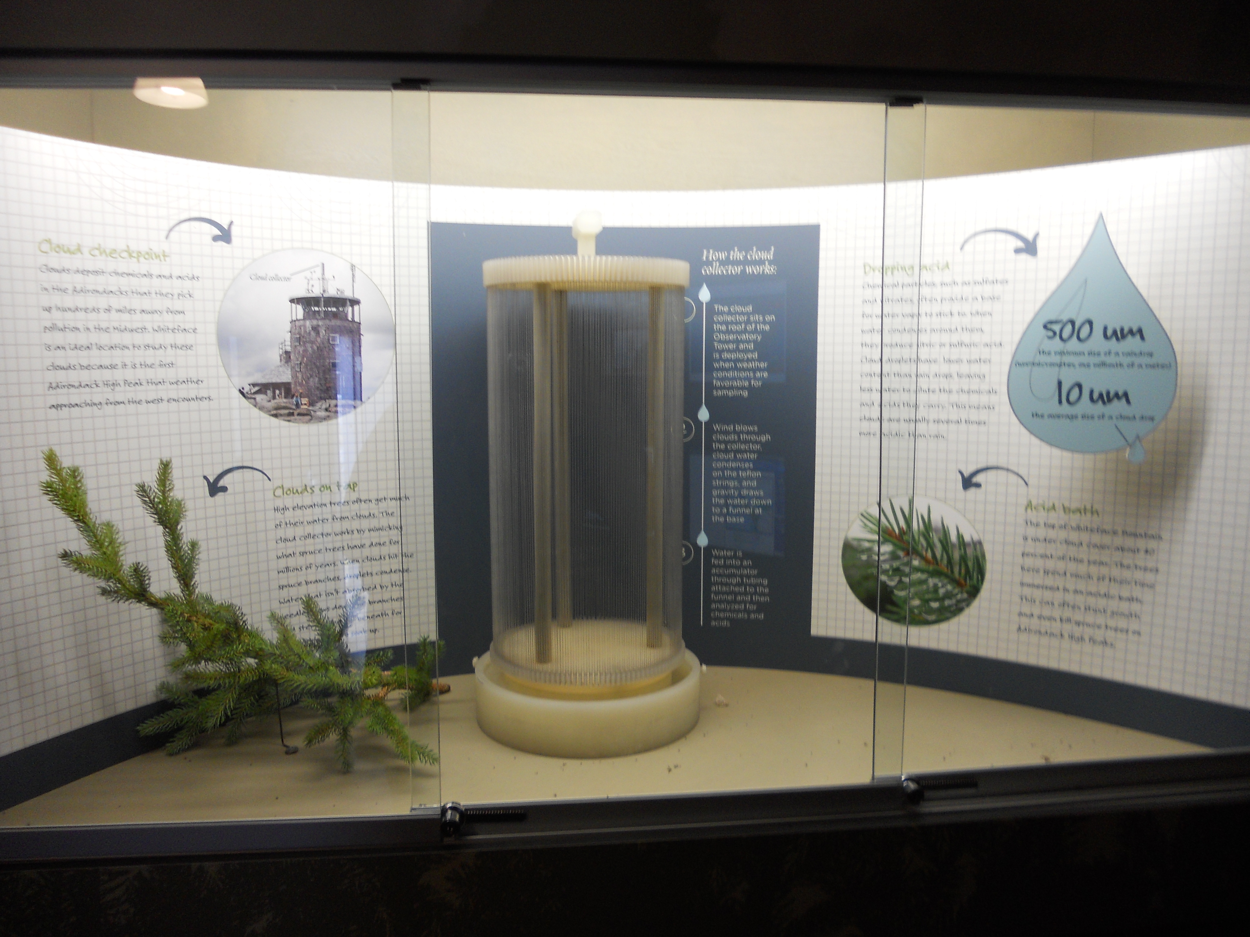 (Original ASRC Cloud Collector. The collector was designed after the water trapping capabilities
of an Adirondack Spruce branch)
(Original ASRC Cloud Collector. The collector was designed after the water trapping capabilities
of an Adirondack Spruce branch)
The following historical video "To Catch A Cloud," from 1983, made by Mohnen highlights the early importance of cloud water collection and research at Whiteface mountain.
(Video: "To Catch A Cloud Excerpt." Mp4: 63MB, 7:28 duration)Measurements In Time
The following table reproduced in part from Schwab et. al., 2016 "Atmospheric Science Research at Whiteface Mountain, NY: Site Description and History" highlights the measurement history at the Whiteface Mountain Field Station ('MML'=Marble Mountain Lodge, 'SUM'=Summit).
| Dates | Measurements | Site |
|---|---|---|
| 1937-1946 | Temperature | SUM |
| 1957-now | Various Meteorological | SUM |
| 1963-1978 | Aerosol Particle Number Concentration | SUM/MML |
| 1973-now | Ozone Concentration | SUM |
| 1975-2020 | High Volume Aerosol Samples | SUM |
| 1976-now | Cloud Water Collection | SUM |
| 1976-now | Precipitation Collection | MML |
| 1984-now | Ozone & Other Trace Gases | MML |
| 1988-now | Ozone & Pollutant Precursor Gases | SUM |
| 1999-now | PM2.5 Mass Concentration | MML |
| 2001-now | PM2.5 Chemical Speciation | MML |
With such a long-standing history of meteorological, and cloud/precipitation chemistry measurements, our datasets are a valuable resource to the public as well as the scientific community. Many ASRC researchers, and their collaborators, are beginning to invest in a "research renaissance" at Whiteface Mountain with new research programs and outreach activities that are bringing new life to the mountain and community. Visit our Scientific Research pages to learn more about research, both past, present, and future that ASRC is leading at Whiteface mountain.
Some Historical Documents
May-June 2015 article in Skiing History on the original Marble Mountain Ski Center
A 1980 Paper "Determination of Cloud Water Acidity at a Mountain Observatory in the Adirondack Mountains of New York State"
A 1980 Paper "Cloud Chemistry and Meteorological Research at Whiteface Mountain"
A Poster presented at the 2015 National Acid Deposition Program Conference "Evolution of Passive Cloud Water Collector From Manual to Fully Automated"
